Nordskot, Norway
Population 56, or something close

Every so often when living on a small island somewhere in the Norwegian Arctic Circle, you need to get out.
When cabin fever started to brew, I might ask someone to drive me over to the mainland. Just five minutes in the boat and I would be so kindly delivered to the village of Nordskot. Population 56, or something like that.
From there I would spend a few hours around town: taking photographs, hiking in the woods, walking along the many beaches picking up shells and trash. If I needed a good long run, or to get father away, I would head out of town along the main road.
I’m being melodramatic about the cabin fever. The first time I walked around the island, I was left thinking it was a tad small. Smaller than expected I guess, and I felt a small moment of panic about living on an island for weeks on end. This thought was fleeting as I have since fallen completely in love with this place.
I never want to leave.
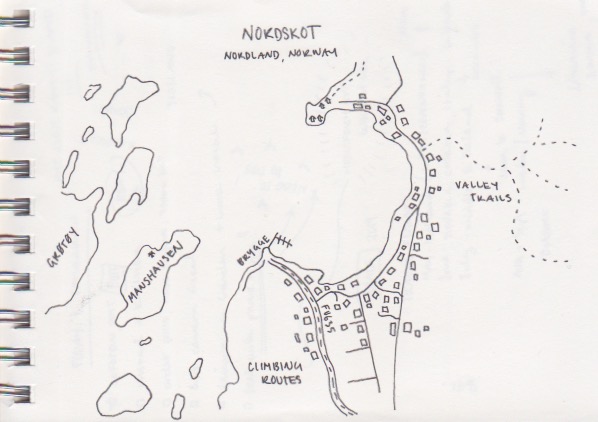
Sometimes I draw little maps of where i have been and this is one of those maps.
You can see how nordskot is Laid out around the bay, our island of Manshausen is just west of the southern shore, across from the Brygge or main Pier.


On this day I walked around the bay of Nordskot, a walk I would take many times in the coming weeks.
A dirt road traces around the bay passing by sweet homes and the trail head that leads off into a valley, surprisingly diverse in its landscape: a ring of mountains to the east, the sea to the west, four lakes kept frozen in the shadows of the mountains, many tiny streams racing all around creating sneaky marshes ready to drench your feet. There is lichen and moss galore in a rainforest kinda way, tree missing bark where moose have been scratching or mating, cracking twigs as moose run away, a little river otter or lynx playing in the largest stream fed from one of the frozen lakes above. One path doesn’t take you into the valley and its forest, but into a field of boulders shroud in more moss and more lichen.


I wasn’t going into the valley on this day, so I walked right past the trail head. I was following the road that traces the bay to its dead end. It ended at the sea, a little beach and a row of red boat houses. Off to the right a little trail offers to take you through a beautifully mossy forest to another beach, one with an unexplained ability to attract shells of various purple hues.


The bay doesn’t seem particularly large, yet Nordskot looked quite far away from the other side. The homes, community buildings, grocery, museum and pier are all gathered on the south side of the bay, with just a few homes built north of it.
In the hour I spent walking down the beach with purple shells, the tide had emptied the bay of water. Watching and eventually recognizing the patterns of the tides, and as they relate to the moon was something about island-living that brought my great joy.

